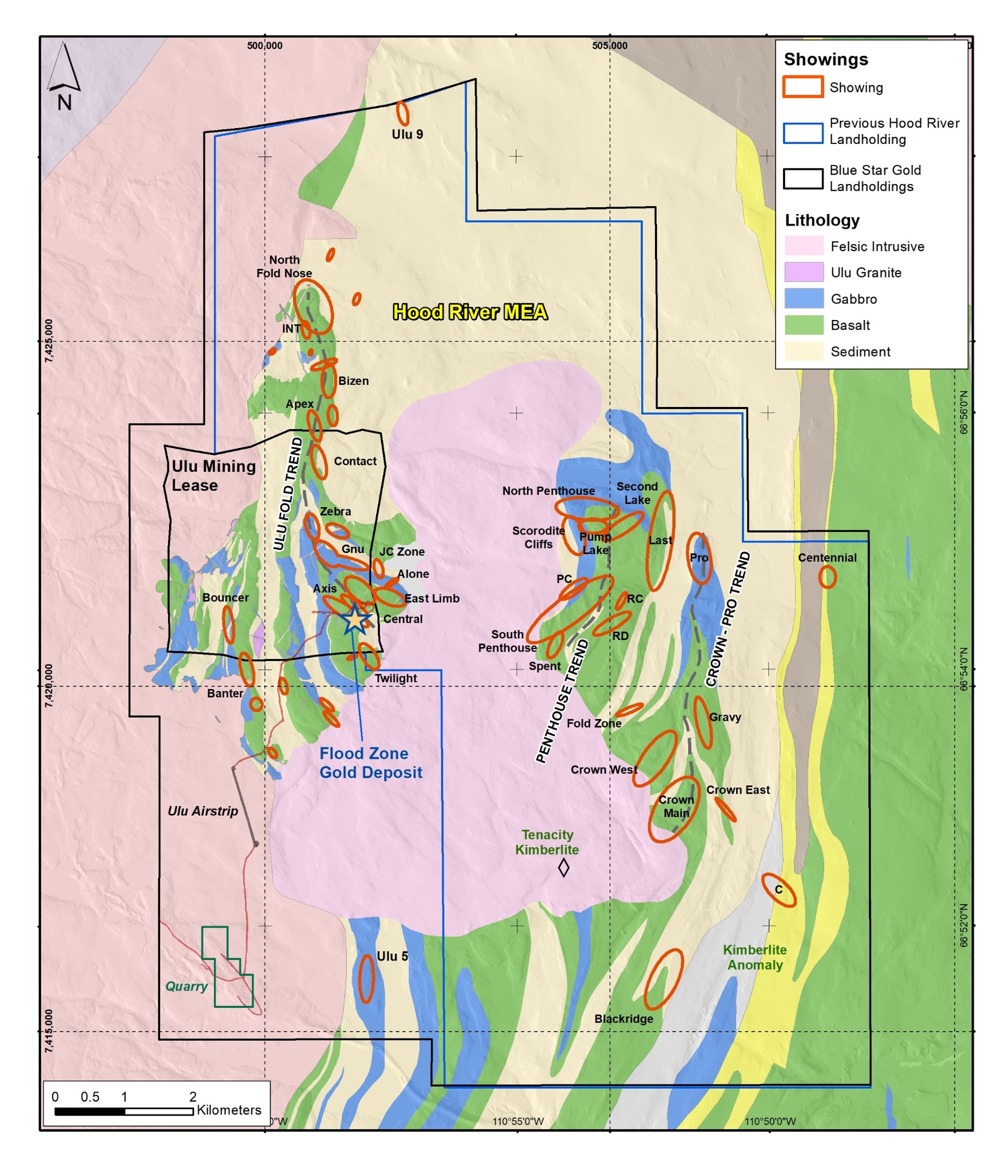
Figure: Map of the Ulu and Hood River Projects displaying numerous targets and gold showings
The Ulu Mining Lease, 947 ha, was initially staked by BHP Minerals as a mineral claim in 1988 under the Canada Mining Regulations and subsequently converted under the same regulations to a renewable 21-year Crown mining lease in 1996. The mining lease, now registered to Blue Star Gold Corp. was renewed as of November 18, 2017 with an expiry date of November 18, 2038.
950 ha contiguous with Hood River Property
Permitted mining lease with both identified gold resources and numerous high-quality drill targets
Permanent infrastructure includes airstrip and camp
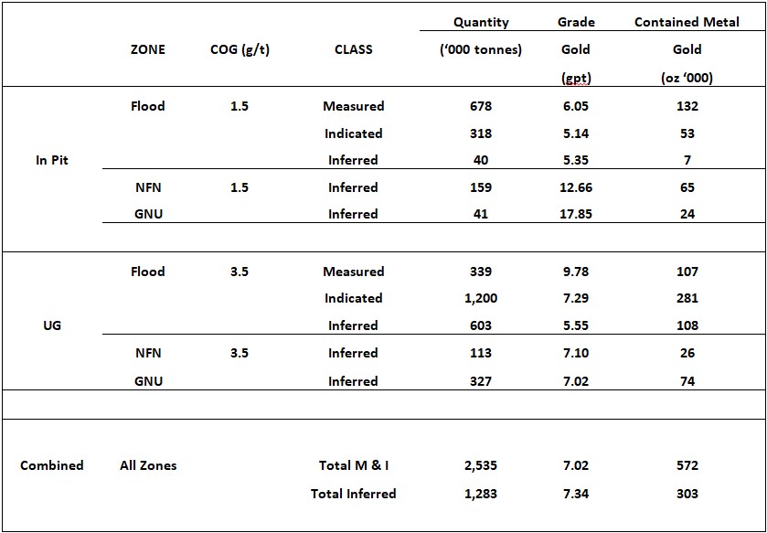
Ulu Gold Project mineral resource estimate:
- M&I 572,000 oz. Au (2.53MT @ 7.02 g/t Au)
- Inf. 303,000 oz. Au (1.28MT @ 7.34 g/t Au)
Excellent resource expansion potential
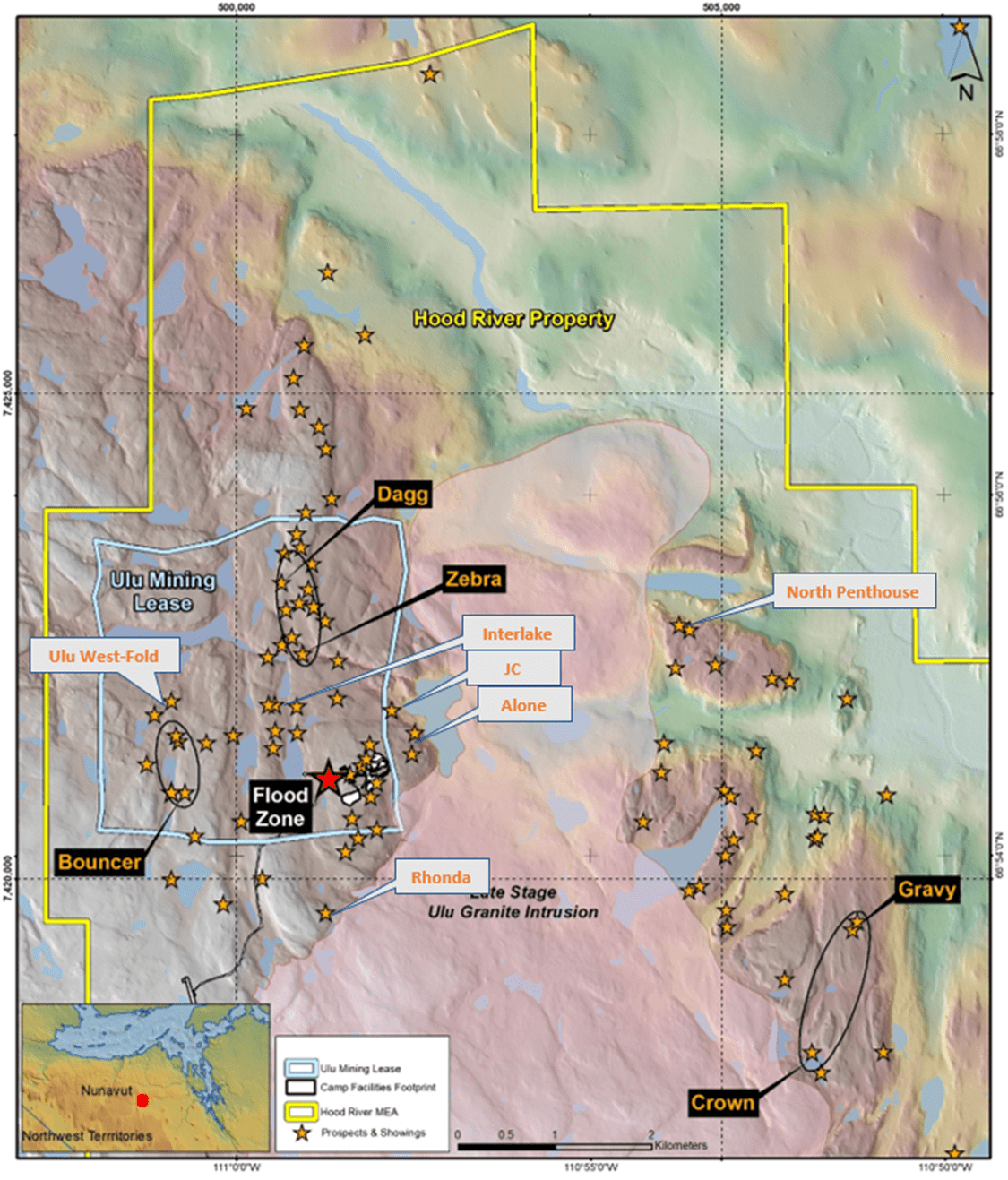
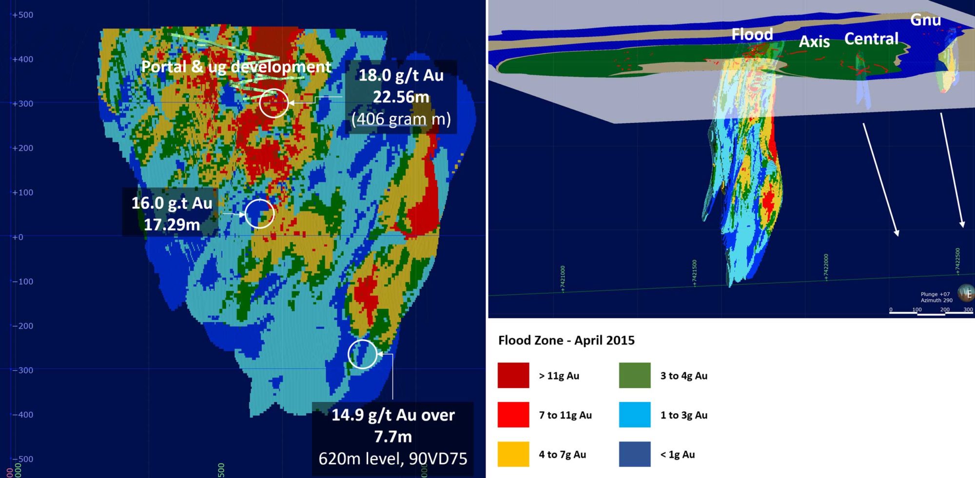
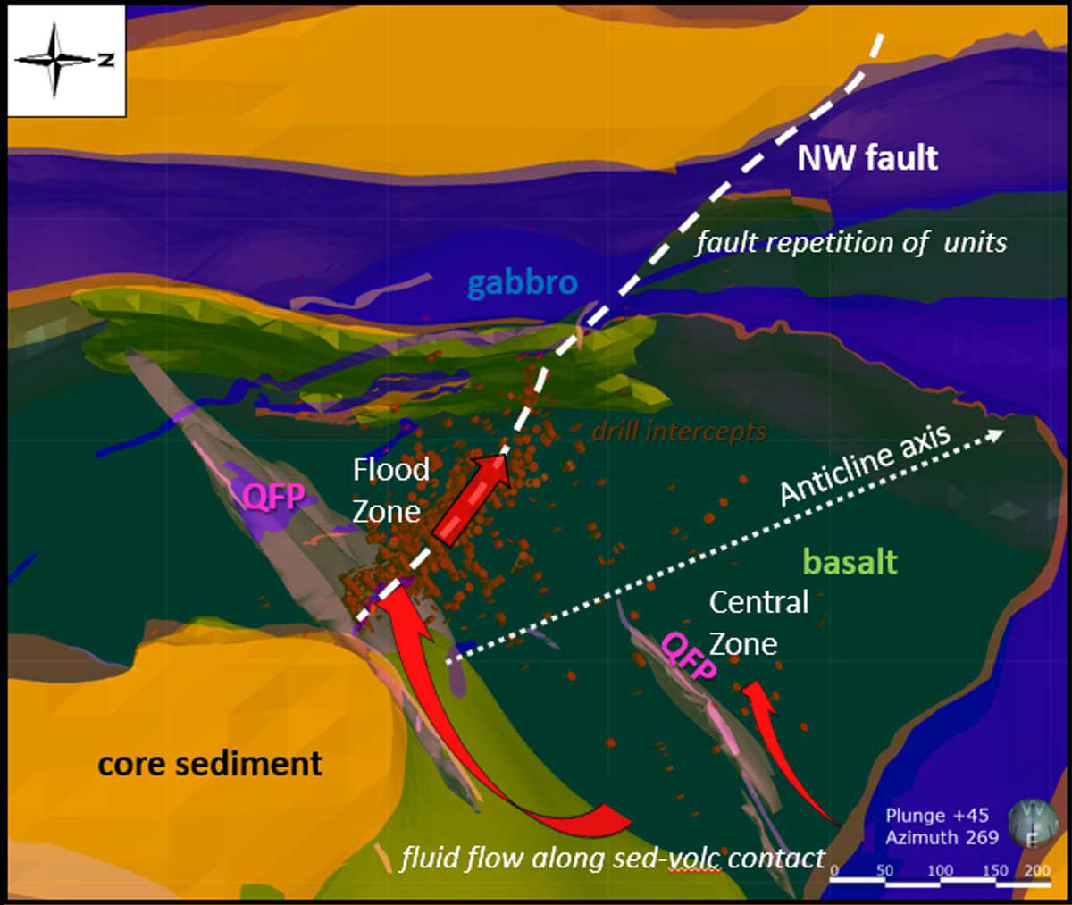
Figure: A significant high-grade gold resource exists at the Flood Zone deposit, and numerous high-grade gold occurrences and priority targets occur throughout the Ulu and Hood River Projects
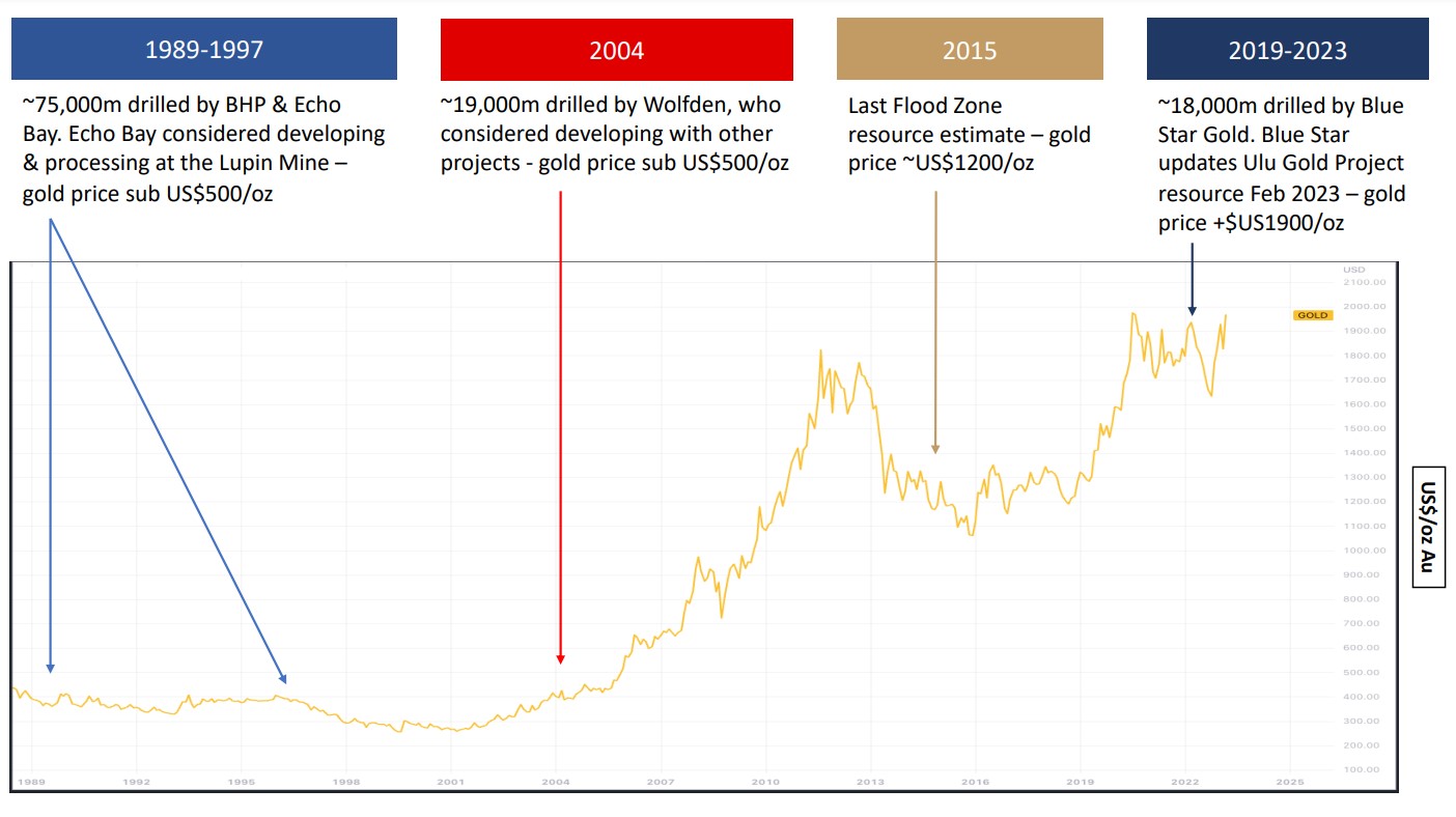
The main deposit, called the Flood Zone, is a northwest-trending, shear hosted anastomosing vein/alteration system that occurs proximal to a basalt-metagreywacke contact at the core of the Ulu Fold. The deposit is steeply dipping to the southwest and has been traced for over 400 metres on surface. The current Flood Zone resource occurs between the surface and a vertical depth of 525 metres. The deepest significant Flood Zone drill intersection assayed 14.9 g/t gold over 7.7 metres at a depth of 610 metres below surface.
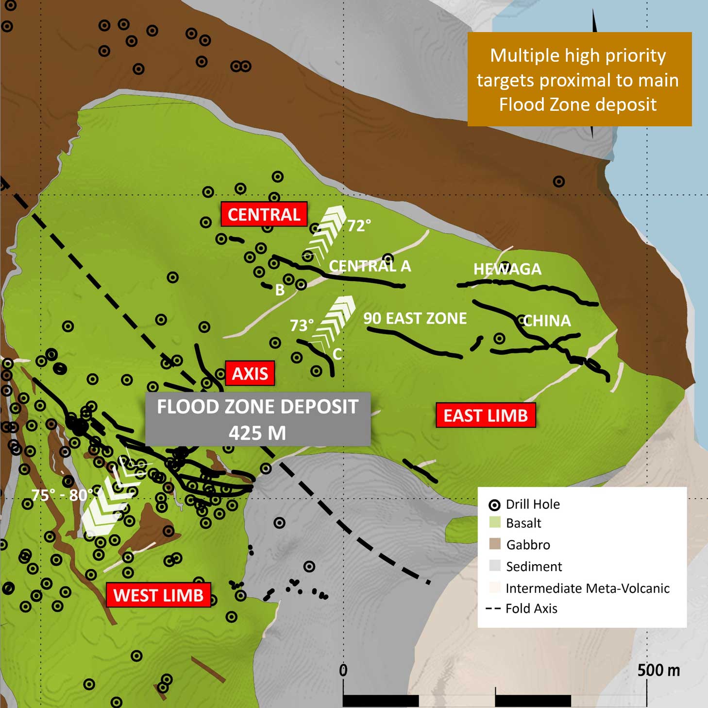
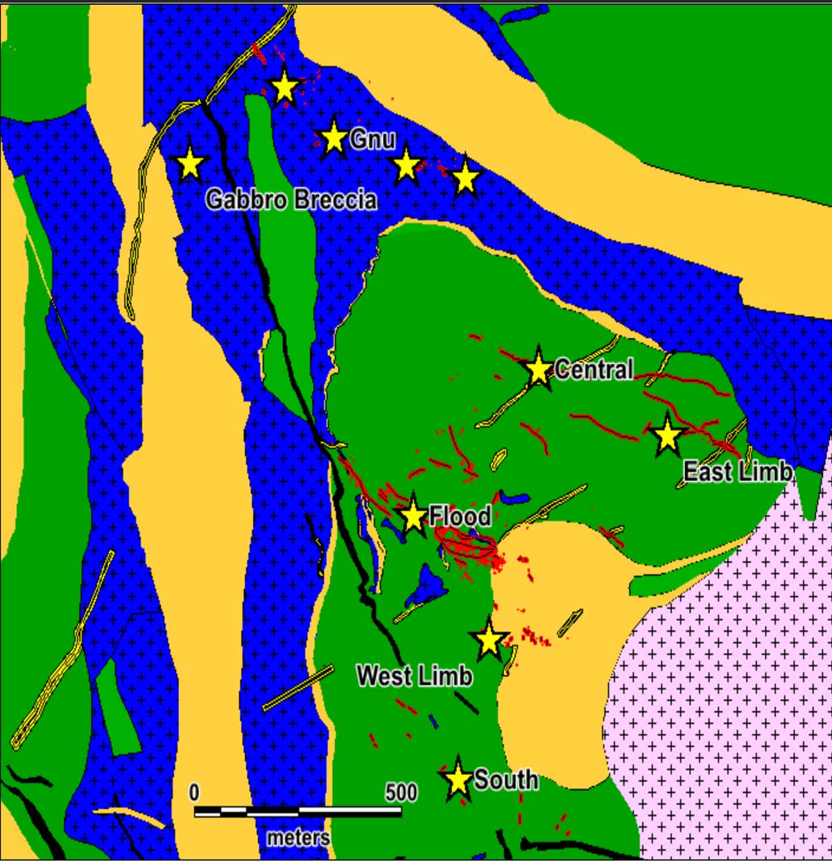
In addition to the high-grade Flood Zone gold deposit, the Ulu mining lease hosts several additional prospective target zones, many of which are spatially related to the axis of the ~5 km long Ulu Fold, which extends from the Ulu lease onto the northern part of the Hood River property and culminates at the North Fold Nose Zone.
The 2023 Exploration Program
Blue Star’s 2023 program included a multi-prong exploration effort across the Company's Ulu Gold Project in Nunavut, including ground-based geophysical surveys, ground-truthing pipeline targets, mapping, lithogeochemical sampling, and prospecting. The program was focused to identify and advance targets throughout Blue Star's highly prospective landholdings to be drill ready for a 2024 discovery program.
Program Highlights:
Several pipeline targets returned elevated gold values, including:
- Central Breccia: 5.75 g/t and 4.91 g/t gold
- Zebra-Dagg Trend: 13.6 g/t, 7.56 g/t, 5.42 g/t and 3.26 g/t gold
- Interlake: 3.90 g/t gold, 9.84% and 5.77% zinc
- South Zone-Twilight: 3.31 g/t gold
- Ulu West Subzone B/C: 27.3 g/t, 7.98 g/t and 6.66 g/t gold
Discussion of Field Results
Mapping focussed on the 5 km long Ulu fold between the Flood Zone gold deposit and the NFN deposit, and the North and South Penthouse areas. Mapping was undertaken at scales of 1:5000 and 1:2500, and pXRF scanning of rock chips was used to determine areas for lithogeochemical sampling to better define and understand the stratigraphic package and differentiate between more prospective lithological units. These map areas host many of the key pipeline prospects. Prospectors focused on areas with limited to no previous sampling, and on confirming and expanding known pipeline targets.
The objective of the program was to revisit and evaluate all the historically defined showings in order to better prioritise their potential. Approximately 80% of the pipeline targets have now been revisited, including base metal targets.
A total of 319 samples were collected this season with assay results ranging from detection limit to 47.6 g/t gold. Samples returning > 1 g/t gold made up 22% of the sample population, > 3 g/t represented 11% of the sample population and samples returning > 5 g/t gold comprised 6% of the sample population. Highlights from the pipeline targets reviewed this season are below.
Ulu Fold Trend Targets
Apex/Bizen: 200-300 metre long acicular arsenopyrite bearing alteration zones in mafic volcanic rocks central to the Ulu Fold located 1500-1700 metres south of the NFN resource area. These trends returned 2.81 g/t, 2.72 g/t, 1.91 g/t, and 1.54 g/t gold.
M-Fold: a complexly folded and sheared mafic volcanic package located west of the Ulu Fold hinge and structurally separated from it by a significant shear zone; highlight result was 9.30 g/t gold.
Zebra: this drill target was further defined using detailed magnetics and mapping to better model the zones within and adjacent to a folded gabbro unit, within tightly folded sedimentary rocks, and at the mafic volcanic and sedimentary rock contact. Samples returned include 7.56 g/t and 3.11 g/t gold.
South Zone – Twilight: this area was mapped in detail in preparation for drill testing of the ~400-metre-long trend of alteration and acicular arsenopyrite mineralisation, interpreted to be a parallel structure to that hosting the Flood Zone gold deposit. Limited sampling this season returned up to 3.31 g/t gold.
New Showing: a new gold showing, called the Fault Showing occurs as part of the Mistake-Dagg-Fault trend immediately north and west of the Zebra showing, is located along the western Ulu Fold mafic volcanic contact with sedimentary units. This showing returned values of 13.6 g/t, 3.26 g/t and 1.4 g/t gold associated with acicular arsenopyrite.
Gnu/Nutaaq Trend Targets
JC Zone: this showing is hosted on the eastern limb of the Ulu Fold in the outer mafic volcanic unit. The main part of the zone was covered with a preliminary induced polarisation survey in order to refine potential drill targets within the Gnu/Nutaaq Trend. Results will be available after interpretations are completed.
Central Breccia: several showings in this area are interpreted to be hosted within the same lithological unit which hosts the Gnu/Nutaaq veins 700 metres to the southeast. Samples from sulphide bearing quartz veins returned 5.75 g/t, 5.42 g/t, 4.91 g/t and 2.56 g/t gold.
Ulu West Targets
Interlake: this showing was confirmed to include a combination of two styles of mineralisation; quartz vein hosted gold, and float boulders of massive sulphide material. The former style of mineralisation returned 3.90 g/t and 2.70 g/t gold while the later returned 0.68 g/t gold, 107 g/t silver, 0.2% cobalt, 2.03% lead and 9.84% zinc. The massive sulphide mineralisation is located on the same mafic volcanic/sedimentary rock contact as the Rhonda showing approximately 2200 metres to the south. More detailed mapping and prospecting of this contact and geophysical surveys will refine the target for future drill testing.
Hunter: this showing was expanded with a grab sample returning 7.30 g/t gold. The showing is hosted in the outer mafic volcanic unit of the Ulu Fold proximal to an inferred break between Ulu West and the Ulu Fold. More detailed work is required to better understand the controls of the mineralisation.
Ulu West-Subzone B/C: several metre to multi-metre scale northerly trending strain zones measuring tens to hundreds of metres in length locally host quartz veins with gossanous haloes in this area. Grab sample highlights from a number of these zones include 27.3 g/t gold from black quartz, 7.98 g/t from black-grey quartz with silvery coloured pyrite, and 6.66 g/t gold from a black quartz vein in foliated biotite rich sediments. These zones are characterised by high bismuth values. This area will receive more detailed mapping and geophysical surveys to determine mineralisation controls in order to bring it to drill ready.
The 2022 Exploration Program Highlights
- 3,700 Metre Drill Program (25 drill holes)
- Testing several targets on the Ulu property, improving the Flood Zone resource model
- 3,055-line-km Airborne Magnetometry Survey and Ground VLF-EM survey
- Surface Mapping and Rock Sampling Program
- 1:2500 scale mapping of the Zebra showing, and work on historical showings on the Hood River Project
- Preliminary review of 58 targets within the more than 100 compiled pipeline showings conducted
The exploration program consisted of 25 drill holes totalling 3,700 metres in the Gnu (Nutaaq) zone, Central-C, Axis, sediment core and select targets in the Flood Zone. The objective was to test target areas, in particular the expanding Gnu (Nutaaq) zone, and the Central-C and Axis zones, located within a few hundred metres of the Flood Zone gold deposit. All drilling was completed with oriented core to assist in geological modelling.
An additional sampling program of historical core from nine drill holes was undertaken to better determine mineralization boundaries due to unsampled shoulders on some mineralized zones. In addition, a 3,055-line-kilometre airborne geophysics program and a regional till sampling program on the Roma project were conducted. Detailed review and prospecting/mapping of 58 of the targets within the more than 100 compiled pipeline showings were also completed.
Majority of resource development/evaluation work completed in much lower gold price environment
It would cost +$60 million CAD to replicate the extensive technical database & infrastructure at the Ulu site
Blue Star Drilling
• 2019 – 1,540 metres (11 surface holes HRP)
• 2020 – 7,624 metres (38 surface holes, Ulu & HRP’s)
• 2021 – 5,030 metres (26 drill holes at the Flood Zone, the NFN target, the Central Zone, and the Gnu area)
• 2022 – 3,700 metres (25 drill holes at the Gnu (Nutaaq) zone, Central-C, Axis, sediment core and select targets in the Flood Zone)
Existing Ulu Project Development
1.7kms of U/G development (ramp , raises)
Airstrip, road network, camp, shop
Highlights
Measured and Indicated Resource of 2.535 million tonnes at an average grade of 7.02 grams per tonne ("g/t") gold ("Au") for 572,000 ounces of gold;
Inferred Mineral Resource of 1.283 million tonnes at an average grade of 7.34 g/t Au for 303,000 ounces of gold;
The updated geological model - using explicit vs the implicit techniques utilized in the previous estimation - has helped define all the reported zones;
Gold mineralisation remains open for further expansion in all contributing zones;
Previously reported metallurgical studies indicate all zones in the MRE can conceptually be co-mingled with +90% gold recovery; and
The multitude of gold showings and zones that have seen only limited detailed assessment provides the Company with excellent resource expansion potential throughout its district scale projects.
Ulu Gold Project Mineral Resource Estimate (“MRE”)*:
The independent and qualified person for the Mineral Resource Estimate, as defined by NI 43-101, is Chris MacInnis, P.Geo (#2059) from ALS-GoldSpot Ltd.
Mineral resources, which are not mineral reserves, do not have demonstrated economic viability. There has been insufficient exploration to define inferred resources above as indicated or measured mineral resources however, it is reasonably expected that the majority of the inferred mineral resources could be upgraded to indicated mineral resources with continued exploration. There is no guarantee that all or any part of a mineral resource can or will be converted into a mineral reserve. The estimate of mineral resources may be materially affected by environmental, permitting, legal, title, taxation, socio-political, marketing, or other relevant issues.
The mineral resources in this estimate were calculated using the Canadian Institute of Mining, Metallurgy and Petroleum (CIM), CIM Standards on Mineral Resources and Reserves, Definitions and Guidelines prepared by the CIM Standing Committee on Reserve Definitions and adopted by CIM Council (CIM 2014 and 2019).
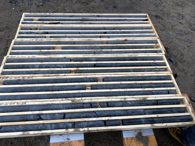
The MRE is underpinned by data from 544 on site diamond drill holes totalling 112,880m of drilling
The MRE is reported at a cut off of 1.5 g/t Au for the conceptual open pit and 3.5 g/t Au for the conceptual underground extraction scenarios. The cut-off grades and potential mining scenarios were calculated using the following parameters; mining cost: $110.00/t UG and $4.13/t OP; G&A and site service costs: $44.20/t; processing cost: $36.3/t; recoveries 92%; gold price US$1750.00 per ounce; and minimum mining width of 2.0 metres in order to meet the requirement that the mineral resources show “reasonable prospects for eventual economic extraction.”
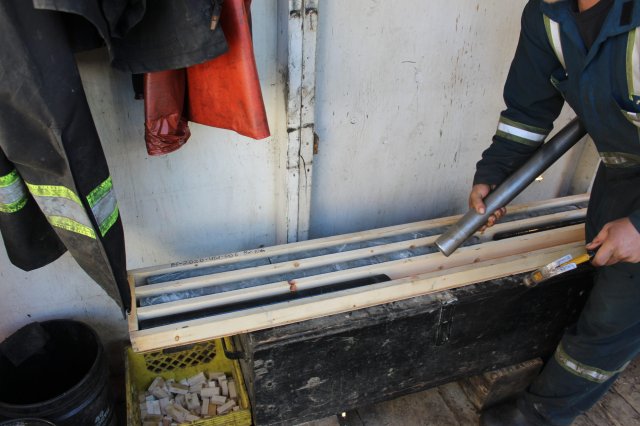
Original Au assays were composited to 1m with 4,231 composites generated in the mineralised domains including 3,934 composites generated for the Flood Zone, 81 composites for the NFN Zone and 154 composites for the Gnu (Nutaaq) Zone.
Grade interpolation was performed by ordinary kriging (OK) for the Flood Zone and inverse power of distance to the third power for all other zones. The informing data was composited to 1.0m for all zones except GNU, which used a 0.75m composite size.
High grade capping supported by statistical analysis was completed on composite data from each zone and was established at 41 g/t Au for the Flood Zone, 35 g/t for the Gnu(Nutaaq) Zone and 41 g/t Au for the NFN Zone.
All figures are rounded to reflect the relative accuracy of the estimates. Metal content is presented in troy ounces (tonnes x grade (g/t) / 31.10348).
The Author is not aware of any known environmental, permitting, legal, title-related, taxation, socio-political or marketing issues or any other relevant issue not reported in the technical report that could materially affect the MRE.
The effective date of the MRE is 08 February 2023.
The Ulu Gold Project MRE is based on 544 diamond drill holes totalling 112,880 m spanning over thirty years to the present along and adjacent to the Ulu Fold Hinge. The MRE represents a significant adjustment in geological and mineralisation style understanding and confidence in the mineralisation modeling to a historic MRE published by a previous operator in 2015 by:
- Modeling distinct high-grade zones with lower grade zones where they occur, and modeling two distinctive styles of mineralisation separately;
- Addition of new assays from drilling campaigns in 2019 through 2022 totaling 88 drill holes for 15,391 m; and
- Modeling portions of the mineral resources with a conceptual open pit mining scenario versus a solely underground extraction scenario.
* As reported in the amended technical report, titled “Technical Report on the Ulu Gold Property, Nunavut, Canada“, dated February 22, 2023 and filed on SEDAR.
In February 22, 2023, the Company reported that the independent and qualified person for the Mineral Resource Estimate, as defined by NI 43-101, is Chris MacInnis, P.Geo (#2059) from ALS-GoldSpot Ltd. had completed an independent Technical Report entitled, Technical Report on the Ulu Project, Kitikmeot Region, Nunavut, Canada.
Ulu Gold Project 43-101 Technical Report
Blue Star is the first company to create GIS databases for all the historic work on the Ulu and Hood River properties
including:
- Scanning and digitizing > 25 historic geology maps
- Digitizing 3,000+ surface mineralization points, 2,700 rock samples, and 2,300 outcrops as well as structural data
- Creating 200+ lithology polygon digital geology maps
- Integrating all surface data into 3D environment
- Rigorous QAQC on historic drill data (477 ddhs) to create master databases for assays, survey data, alteration and drill composites
- Creating 3D solids for alteration, lithologies, mineralization
Digital compilation into 3D has allowed for identification of likely controls on gold transport and localization at Ulu. These include:
- Fluid focus along fold axis (1st order control) at lithologic contacts with high rheology contrast (basalt-sediment)
- Capture of the fluid by planar quartz-feldspar porphyry dikes (2nd order)
- Deposition of mineralization in NW trending fractures (3rd order capture) within competent mafic volcanic unit. High-iron tholeiitic basalt = same host for Doris Au Mine and HGZ at Red Lake (which also has acicular arsenopyrite)
Recognition of these structural controls allows for targeting of similar settings along the Ulu Fold and Hood River Property.
Amphibolite Grade Gold Mine
Examples
Eleonore
Quebec: Aspy > po > py. Tourmaline rich. 7+ M oz Au. Hedenbergite alteration. Ductile deformation.
Borden Lake
Ontario. 4.17 MT @ 6.38 g/t AuPo » Py. Ductile deformation.
Lupin
Nunavut. 3.4 M oz Au produced at 9.0 g/t. Aspy + loellingite + po with quartz + hedenbergite.
Hemlo
Ontario. 21 M Oz Au total. Golden Giant grade = 11.47 g Au.
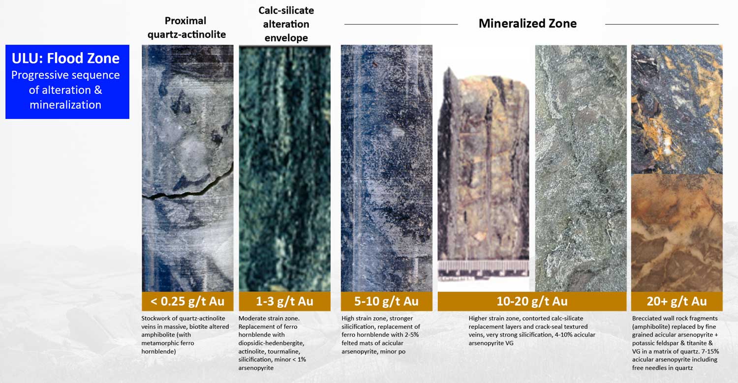
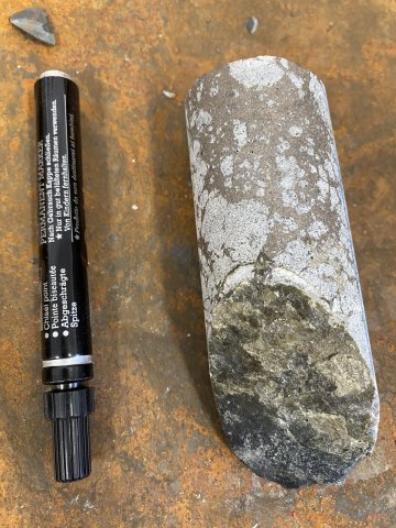
Flood Zone
- Grain boundaries + free gold. Calc-silicate alteration including actinolite and diopsidic hedenbergite.
- Features consistent with amphibolite grade Au deposits include ductile deformation, arsenopyrite + lollingite + pyrrhotite ore mineral assemblage, calc-silicate alteration.
Great Bear Resources’ LP Fault Zone
Mineralization is in amphibolite grades, 15.45 g/t Au over 25.15 m (389 gram metres)

2020 Drill Program
Ulu Video Footage
Overview
Figure: Map of the Ulu and Hood River Projects displaying numerous targets and gold showings
The Ulu Mining Lease, 947 ha, was initially staked by BHP Minerals as a mineral claim in 1988 under the Canada Mining Regulations and subsequently converted under the same regulations to a renewable 21-year Crown mining lease in 1996. The mining lease, now registered to Blue Star Gold Corp. was renewed as of November 18, 2017 with an expiry date of November 18, 2038.
950 ha contiguous with Hood River Property
Permitted mining lease with both identified gold resources and numerous high-quality drill targets
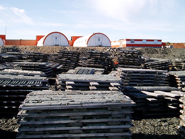
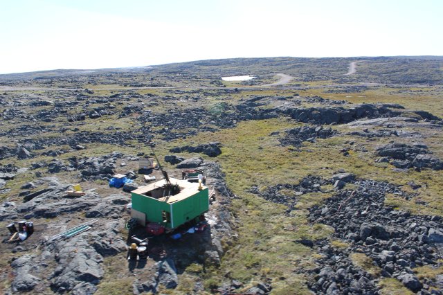
Permanent infrastructure includes airstrip and camp
Ulu Gold Project mineral resource estimate:
- M&I 572,000 oz. Au (2.53MT @ 7.02 g/t Au)
- Inf. 303,000 oz. Au (1.28MT @ 7.34 g/t Au)
Excellent resource expansion potential
Geological Summary
Figure: A significant high-grade gold resource exists at the Flood Zone deposit, and numerous high-grade gold occurrences and priority targets occur throughout the Ulu and Hood River Projects
The main deposit, called the Flood Zone, is a northwest-trending, shear hosted anastomosing vein/alteration system that occurs proximal to a basalt-metagreywacke contact at the core of the Ulu Fold. The deposit is steeply dipping to the southwest and has been traced for over 400 metres on surface. The current Flood Zone resource occurs between the surface and a vertical depth of 525 metres. The deepest significant Flood Zone drill intersection assayed 14.9 g/t gold over 7.7 metres at a depth of 610 metres below surface.
In addition to the high-grade Flood Zone gold deposit, the Ulu mining lease hosts several additional prospective target zones, many of which are spatially related to the axis of the ~5 km long Ulu Fold, which extends from the Ulu lease onto the northern part of the Hood River property and culminates at the North Fold Nose Zone.
Exploration Program
The 2023 Exploration Program
Blue Star’s 2023 program included a multi-prong exploration effort across the Company's Ulu Gold Project in Nunavut, including ground-based geophysical surveys, ground-truthing pipeline targets, mapping, lithogeochemical sampling, and prospecting. The program was focused to identify and advance targets throughout Blue Star's highly prospective landholdings to be drill ready for a 2024 discovery program.
Program Highlights:
Several pipeline targets returned elevated gold values, including:
- Central Breccia: 5.75 g/t and 4.91 g/t gold
- Zebra-Dagg Trend: 13.6 g/t, 7.56 g/t, 5.42 g/t and 3.26 g/t gold
- Interlake: 3.90 g/t gold, 9.84% and 5.77% zinc
- South Zone-Twilight: 3.31 g/t gold
- Ulu West Subzone B/C: 27.3 g/t, 7.98 g/t and 6.66 g/t gold
Discussion of Field Results
Mapping focussed on the 5 km long Ulu fold between the Flood Zone gold deposit and the NFN deposit, and the North and South Penthouse areas. Mapping was undertaken at scales of 1:5000 and 1:2500, and pXRF scanning of rock chips was used to determine areas for lithogeochemical sampling to better define and understand the stratigraphic package and differentiate between more prospective lithological units. These map areas host many of the key pipeline prospects. Prospectors focused on areas with limited to no previous sampling, and on confirming and expanding known pipeline targets.
The objective of the program was to revisit and evaluate all the historically defined showings in order to better prioritise their potential. Approximately 80% of the pipeline targets have now been revisited, including base metal targets.
A total of 319 samples were collected this season with assay results ranging from detection limit to 47.6 g/t gold. Samples returning > 1 g/t gold made up 22% of the sample population, > 3 g/t represented 11% of the sample population and samples returning > 5 g/t gold comprised 6% of the sample population. Highlights from the pipeline targets reviewed this season are below.
Ulu Fold Trend Targets
Apex/Bizen: 200-300 metre long acicular arsenopyrite bearing alteration zones in mafic volcanic rocks central to the Ulu Fold located 1500-1700 metres south of the NFN resource area. These trends returned 2.81 g/t, 2.72 g/t, 1.91 g/t, and 1.54 g/t gold.
M-Fold: a complexly folded and sheared mafic volcanic package located west of the Ulu Fold hinge and structurally separated from it by a significant shear zone; highlight result was 9.30 g/t gold.
Zebra: this drill target was further defined using detailed magnetics and mapping to better model the zones within and adjacent to a folded gabbro unit, within tightly folded sedimentary rocks, and at the mafic volcanic and sedimentary rock contact. Samples returned include 7.56 g/t and 3.11 g/t gold.
South Zone – Twilight: this area was mapped in detail in preparation for drill testing of the ~400-metre-long trend of alteration and acicular arsenopyrite mineralisation, interpreted to be a parallel structure to that hosting the Flood Zone gold deposit. Limited sampling this season returned up to 3.31 g/t gold.
New Showing: a new gold showing, called the Fault Showing occurs as part of the Mistake-Dagg-Fault trend immediately north and west of the Zebra showing, is located along the western Ulu Fold mafic volcanic contact with sedimentary units. This showing returned values of 13.6 g/t, 3.26 g/t and 1.4 g/t gold associated with acicular arsenopyrite.
Gnu/Nutaaq Trend Targets
JC Zone: this showing is hosted on the eastern limb of the Ulu Fold in the outer mafic volcanic unit. The main part of the zone was covered with a preliminary induced polarisation survey in order to refine potential drill targets within the Gnu/Nutaaq Trend. Results will be available after interpretations are completed.
Central Breccia: several showings in this area are interpreted to be hosted within the same lithological unit which hosts the Gnu/Nutaaq veins 700 metres to the southeast. Samples from sulphide bearing quartz veins returned 5.75 g/t, 5.42 g/t, 4.91 g/t and 2.56 g/t gold.
Ulu West Targets
Interlake: this showing was confirmed to include a combination of two styles of mineralisation; quartz vein hosted gold, and float boulders of massive sulphide material. The former style of mineralisation returned 3.90 g/t and 2.70 g/t gold while the later returned 0.68 g/t gold, 107 g/t silver, 0.2% cobalt, 2.03% lead and 9.84% zinc. The massive sulphide mineralisation is located on the same mafic volcanic/sedimentary rock contact as the Rhonda showing approximately 2200 metres to the south. More detailed mapping and prospecting of this contact and geophysical surveys will refine the target for future drill testing.
Hunter: this showing was expanded with a grab sample returning 7.30 g/t gold. The showing is hosted in the outer mafic volcanic unit of the Ulu Fold proximal to an inferred break between Ulu West and the Ulu Fold. More detailed work is required to better understand the controls of the mineralisation.
Ulu West-Subzone B/C: several metre to multi-metre scale northerly trending strain zones measuring tens to hundreds of metres in length locally host quartz veins with gossanous haloes in this area. Grab sample highlights from a number of these zones include 27.3 g/t gold from black quartz, 7.98 g/t from black-grey quartz with silvery coloured pyrite, and 6.66 g/t gold from a black quartz vein in foliated biotite rich sediments. These zones are characterised by high bismuth values. This area will receive more detailed mapping and geophysical surveys to determine mineralisation controls in order to bring it to drill ready.
The 2022 Exploration Program Highlights
- 3,700 Metre Drill Program (25 drill holes)
- Testing several targets on the Ulu property, improving the Flood Zone resource model
- 3,055-line-km Airborne Magnetometry Survey and Ground VLF-EM survey
- Surface Mapping and Rock Sampling Program
- 1:2500 scale mapping of the Zebra showing, and work on historical showings on the Hood River Project
- Preliminary review of 58 targets within the more than 100 compiled pipeline showings conducted
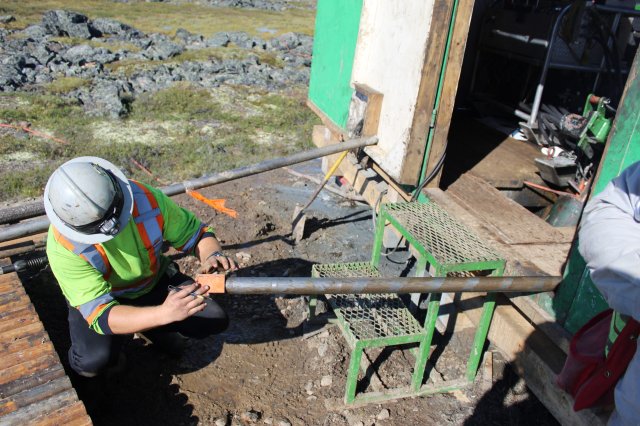
The exploration program consisted of 25 drill holes totalling 3,700 metres in the Gnu (Nutaaq) zone, Central-C, Axis, sediment core and select targets in the Flood Zone. The objective was to test target areas, in particular the expanding Gnu (Nutaaq) zone, and the Central-C and Axis zones, located within a few hundred metres of the Flood Zone gold deposit. All drilling was completed with oriented core to assist in geological modelling.
An additional sampling program of historical core from nine drill holes was undertaken to better determine mineralization boundaries due to unsampled shoulders on some mineralized zones. In addition, a 3,055-line-kilometre airborne geophysics program and a regional till sampling program on the Roma project were conducted. Detailed review and prospecting/mapping of 58 of the targets within the more than 100 compiled pipeline showings were also completed.
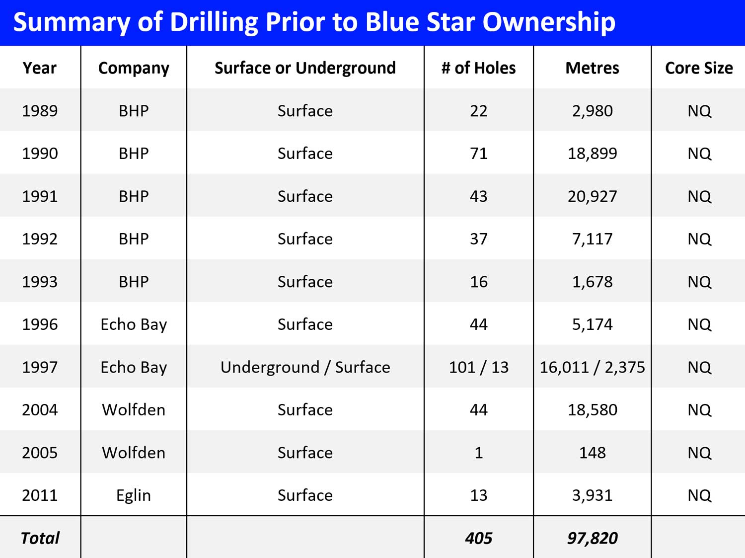
Drilling Development History
Majority of resource development/evaluation work completed in much lower gold price environment
It would cost +$60 million CAD to replicate the extensive technical database & infrastructure at the Ulu site
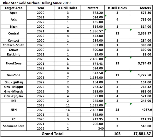
Blue Star Drilling
• 2019 – 1,540 metres (11 surface holes HRP)
• 2020 – 7,624 metres (38 surface holes, Ulu & HRP’s)
• 2021 – 5,030 metres (26 drill holes at the Flood Zone, the NFN target, the Central Zone, and the Gnu area)
• 2022 – 3,700 metres (25 drill holes at the Gnu (Nutaaq) zone, Central-C, Axis, sediment core and select targets in the Flood Zone)
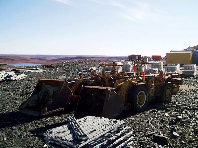
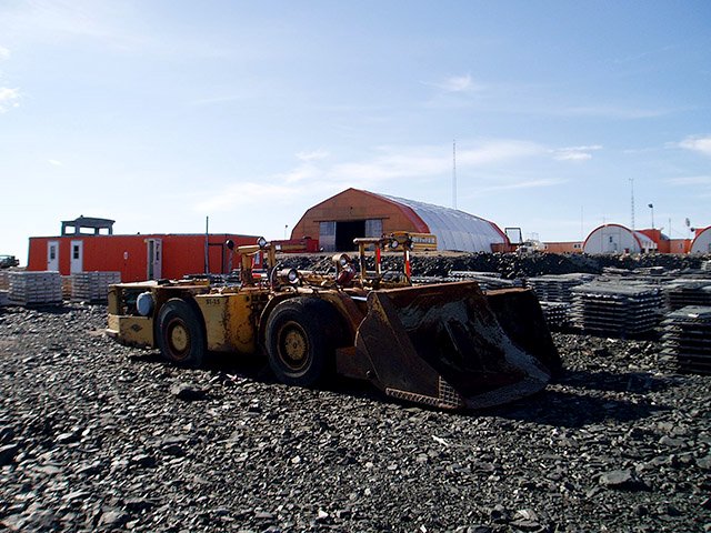
Existing Ulu Project Development
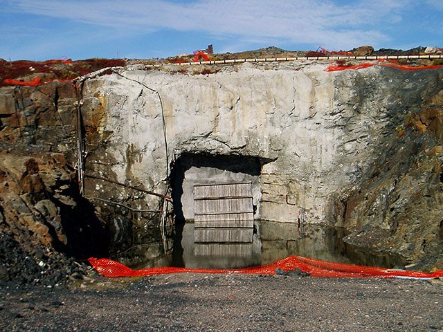
1.7kms of U/G development (ramp , raises)
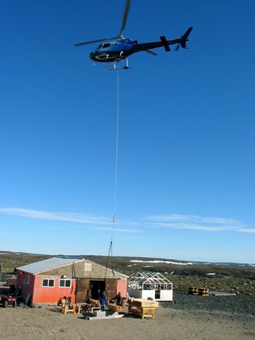
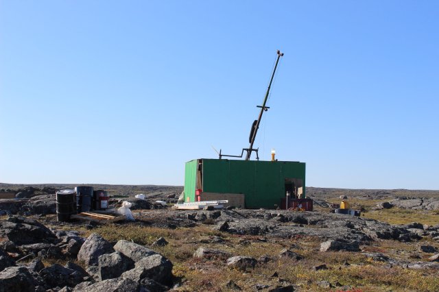
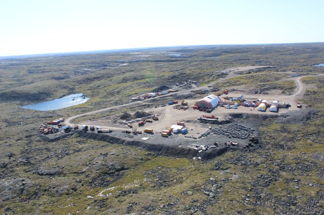
Airstrip, road network, camp, shop
Gold Resources
Highlights
Measured and Indicated Resource of 2.535 million tonnes at an average grade of 7.02 grams per tonne ("g/t") gold ("Au") for 572,000 ounces of gold;
Inferred Mineral Resource of 1.283 million tonnes at an average grade of 7.34 g/t Au for 303,000 ounces of gold;
The updated geological model - using explicit vs the implicit techniques utilized in the previous estimation - has helped define all the reported zones;
Gold mineralisation remains open for further expansion in all contributing zones;
Previously reported metallurgical studies indicate all zones in the MRE can conceptually be co-mingled with +90% gold recovery; and
The multitude of gold showings and zones that have seen only limited detailed assessment provides the Company with excellent resource expansion potential throughout its district scale projects.
Ulu Gold Project Mineral Resource Estimate (“MRE”)*:
The independent and qualified person for the Mineral Resource Estimate, as defined by NI 43-101, is Chris MacInnis, P.Geo (#2059) from ALS-GoldSpot Ltd.
Mineral resources, which are not mineral reserves, do not have demonstrated economic viability. There has been insufficient exploration to define inferred resources above as indicated or measured mineral resources however, it is reasonably expected that the majority of the inferred mineral resources could be upgraded to indicated mineral resources with continued exploration. There is no guarantee that all or any part of a mineral resource can or will be converted into a mineral reserve. The estimate of mineral resources may be materially affected by environmental, permitting, legal, title, taxation, socio-political, marketing, or other relevant issues.
The mineral resources in this estimate were calculated using the Canadian Institute of Mining, Metallurgy and Petroleum (CIM), CIM Standards on Mineral Resources and Reserves, Definitions and Guidelines prepared by the CIM Standing Committee on Reserve Definitions and adopted by CIM Council (CIM 2014 and 2019).
The MRE is underpinned by data from 544 on site diamond drill holes totalling 112,880m of drilling
The MRE is reported at a cut off of 1.5 g/t Au for the conceptual open pit and 3.5 g/t Au for the conceptual underground extraction scenarios. The cut-off grades and potential mining scenarios were calculated using the following parameters; mining cost: $110.00/t UG and $4.13/t OP; G&A and site service costs: $44.20/t; processing cost: $36.3/t; recoveries 92%; gold price US$1750.00 per ounce; and minimum mining width of 2.0 metres in order to meet the requirement that the mineral resources show “reasonable prospects for eventual economic extraction.”
Original Au assays were composited to 1m with 4,231 composites generated in the mineralised domains including 3,934 composites generated for the Flood Zone, 81 composites for the NFN Zone and 154 composites for the Gnu (Nutaaq) Zone.
Grade interpolation was performed by ordinary kriging (OK) for the Flood Zone and inverse power of distance to the third power for all other zones. The informing data was composited to 1.0m for all zones except GNU, which used a 0.75m composite size.
High grade capping supported by statistical analysis was completed on composite data from each zone and was established at 41 g/t Au for the Flood Zone, 35 g/t for the Gnu(Nutaaq) Zone and 41 g/t Au for the NFN Zone.
All figures are rounded to reflect the relative accuracy of the estimates. Metal content is presented in troy ounces (tonnes x grade (g/t) / 31.10348).
The Author is not aware of any known environmental, permitting, legal, title-related, taxation, socio-political or marketing issues or any other relevant issue not reported in the technical report that could materially affect the MRE.
The effective date of the MRE is 08 February 2023.
The Ulu Gold Project MRE is based on 544 diamond drill holes totalling 112,880 m spanning over thirty years to the present along and adjacent to the Ulu Fold Hinge. The MRE represents a significant adjustment in geological and mineralisation style understanding and confidence in the mineralisation modeling to a historic MRE published by a previous operator in 2015 by:
- Modeling distinct high-grade zones with lower grade zones where they occur, and modeling two distinctive styles of mineralisation separately;
- Addition of new assays from drilling campaigns in 2019 through 2022 totaling 88 drill holes for 15,391 m; and
- Modeling portions of the mineral resources with a conceptual open pit mining scenario versus a solely underground extraction scenario.
* As reported in the amended technical report, titled “Technical Report on the Ulu Gold Property, Nunavut, Canada“, dated February 22, 2023 and filed on SEDAR.
Technical Report
In February 22, 2023, the Company reported that the independent and qualified person for the Mineral Resource Estimate, as defined by NI 43-101, is Chris MacInnis, P.Geo (#2059) from ALS-GoldSpot Ltd. had completed an independent Technical Report entitled, Technical Report on the Ulu Project, Kitikmeot Region, Nunavut, Canada.
Ulu Gold Project 43-101 Technical Report
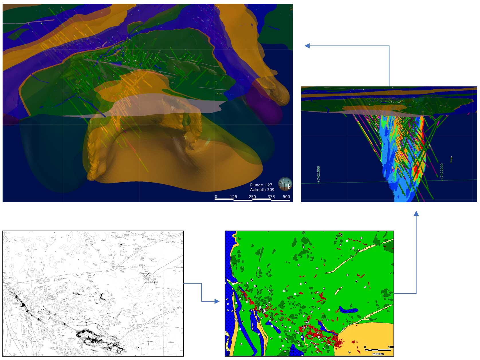
Flood & Gnu Resource 3D Model
Digital Capture of Historical Data
Blue Star is the first company to create GIS databases for all the historic work on the Ulu and Hood River properties
including:
- Scanning and digitizing > 25 historic geology maps
- Digitizing 3,000+ surface mineralization points, 2,700 rock samples, and 2,300 outcrops as well as structural data
- Creating 200+ lithology polygon digital geology maps
- Integrating all surface data into 3D environment
- Rigorous QAQC on historic drill data (477 ddhs) to create master databases for assays, survey data, alteration and drill composites
- Creating 3D solids for alteration, lithologies, mineralization
Key Controls on Mineralization Identified
Digital compilation into 3D has allowed for identification of likely controls on gold transport and localization at Ulu. These include:
- Fluid focus along fold axis (1st order control) at lithologic contacts with high rheology contrast (basalt-sediment)
- Capture of the fluid by planar quartz-feldspar porphyry dikes (2nd order)
- Deposition of mineralization in NW trending fractures (3rd order capture) within competent mafic volcanic unit. High-iron tholeiitic basalt = same host for Doris Au Mine and HGZ at Red Lake (which also has acicular arsenopyrite)
Recognition of these structural controls allows for targeting of similar settings along the Ulu Fold and Hood River Property.
Alteration AU Grade Deposit Examples
Amphibolite Grade Gold Mine
Examples
Eleonore
Quebec: Aspy > po > py. Tourmaline rich. 7+ M oz Au. Hedenbergite alteration. Ductile deformation.
Borden Lake
Ontario. 4.17 MT @ 6.38 g/t AuPo » Py. Ductile deformation.
Lupin
Nunavut. 3.4 M oz Au produced at 9.0 g/t. Aspy + loellingite + po with quartz + hedenbergite.
Hemlo
Ontario. 21 M Oz Au total. Golden Giant grade = 11.47 g Au.
Flood Zone
- Grain boundaries + free gold. Calc-silicate alteration including actinolite and diopsidic hedenbergite.
- Features consistent with amphibolite grade Au deposits include ductile deformation, arsenopyrite + lollingite + pyrrhotite ore mineral assemblage, calc-silicate alteration.
Great Bear Resources’ LP Fault Zone
Mineralization is in amphibolite grades, 15.45 g/t Au over 25.15 m (389 gram metres)
Flood Core Zones
Flood Core Zones
Media Gallery
2020 Drill Program
Ulu Video Footage