Vancouver, British Columbia--(Newsfile Corp. - April 3, 2025) - Blue Star Gold Corp. (TSXV: BAU) (OTCQB: BAUFF) (FSE: 5WP0) ("Blue Star" or the "Company"), a leading explorer in Canada's North, announces significant advances in the understanding of its flagship Flood Zone deposit, located in the West Kitikmeot Region of Nunavut. Strong potential exists for expansion of the deposit down plunge of existing deep high-grade gold intercepts.
Flood Zone Deep Highlights
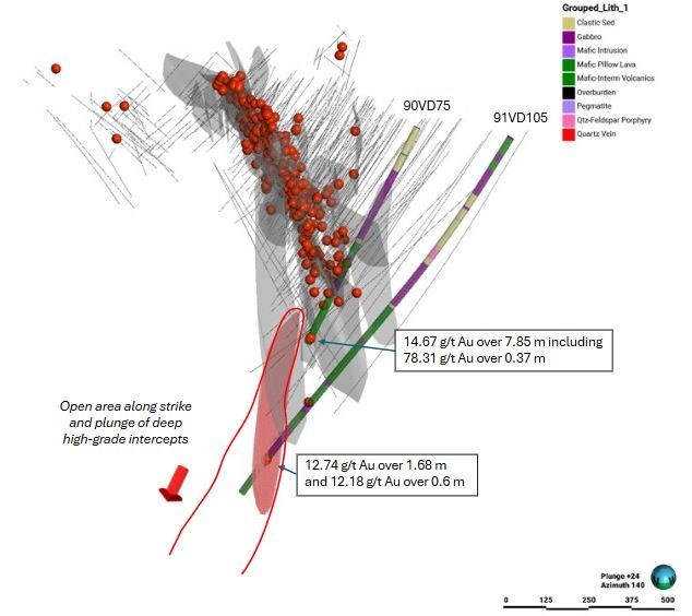
- Deep high-grade gold intercepts with no follow-up drilling include 12.74 g/t Au over 1.68 metres and 12.18 g/t Au over 0.6 metres in 91VD105 at ~950 metres depth and 14.67 g/t over 7.85 metres in 90VD75 at ~590 metres depth.
- New structural model indicates that veins at the northwest end of the mineralization rotate towards the south, away from the southeast trend of the known system.
- The key A1-basalt — sedimentary rock contact may be offset at depth and can be targeted where this contact intersects the projected vein system.
- Significant potential for resource expansion exists down-plunge.
"Based on our recent studies there are several new areas to target within the Flood Zone," said Grant Ewing, CEO of Blue Star. "The deep Flood Zone targets are some of the most interesting because the mineralization has never been drilled at depth along plunge. Now that we understand how the structures and mineralization are behaving at depth, the follow-up drilling to expand the resource can be planned with more confidence."

Figure 1: Oblique Sectional View of the Flood Zone Deposit Looking Southeast. Gold Intercepts >10 g/t Au are Shown as Red Spheres. Vein Models are Shown as Grey Planes. Resource Expansion Vein Target Area is Shown as a Reddish Plane.
To view an enhanced version of this graphic, please visit:
https://images.newsfilecorp.com/files/2421/247186_48bc8023e47a1891_003full.jpg

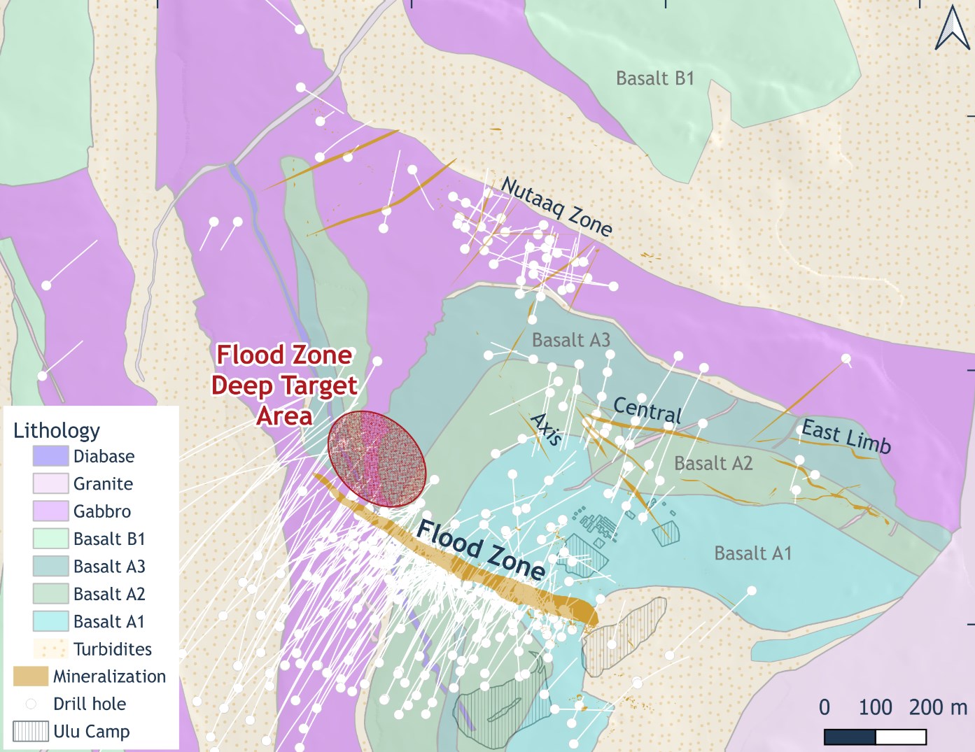
Figure 2: Plan Map of the High-Grade Flood Zone Deposit and Nearby Targets Including a Projection of the Flood Zone Deep Target Area.
To view an enhanced version of this graphic, please visit:
https://images.newsfilecorp.com/files/2421/247186_48bc8023e47a1891_004full.jpg
Discussion of the Flood Zone
The Flood Zone deposit is an anastomosing trend of gold and acicular arsenopyrite in quartz veins and silicified high-iron, high-titanium mafic volcanic rock which follows the trace of a steeply southwest dipping, southeast trending structure that crosscuts the stratigraphy of the western limb of the Ulu Fold. It has characteristics of a mesozonal orogenic gold system with both brittle and ductile textures, including silicification and quartz 'flooding' surrounding mineralized brecciated mafic volcanic rocks, and ductile deformation and folding of the mineralized zone. The mineralization is steeply dipping parallel with the main southeast fault. Alteration halos up to 20 metres wide envelop mineralization and consist of silicification and potassium enrichment, defined by a calc-silicate mineral assemblage. The Flood Zone is ~450 metres long and has been drilled to ~1,000 metres depth. It remains open along plunge and down dip.
The Ulu Fold is a five-kilometre long, moderately northwest plunging anticline which served as a primary conduit of mineralizing fluids during ore formation, which were then channeled into the second order southeast trending faults and shears, which now host the mineralization, including the Flood, Central and Axis Zones, and many other less well-evaluated zones.
Historical Work
The Flood Zone was first identified by BHP in 1989 during a multi-year regional exploration program of greenstone belts in the Slave Craton, focusing on major volcanic-sedimentary rock contacts and areas of structural complexity. The 400-metre-long trend of arsenopyrite-bearing frost-heaved boulders, which defines the surface expression of the Flood Zone, was discovered by Eugene Flood, and yielded assays of 20 to 40 g/t Au. The discovery holes in 1989 intersected strongly brecciated and silicified mafic volcanic rock with acicular arsenopyrite and sulphides including pyrite, pyrrhotite and chalcopyrite, and returned multiple high-grade intervals. These include 5.52 g/t Au over 16.1 metres near surface and 13.99 g/t Au over 6.0 metres at 35 metres below surface in hole 89VD01, 5.52 g/t Au over 16.10 metres in hole 89VD02, 13.99 g/t Au over 6.0 metres in hole 89VD04, and 9.74 g/t Au over 7.17 metres in hole 89VD10.
Blue Star's Recent Work
Since acquiring the Ulu Gold Project in 2019, Blue Star has undertaken a systematic approach to build the understanding of the known mineralization including lithological, structural and geochemical controls of the mineralization, and has moved forward to identify and refine targets within untested areas of the Flood Zone deposit for expansion.
A structural study has updated the understanding of vein geometries. Key to the new interpretation is the recognition that the generally southeast trending mineralization flexes to a more southerly orientation at its northwest extent in the deepest part of the known system. This opens up additional opportunities for deposit expansion. A geochemical study defined the mafic stratigraphy resolving a close association of the Flood Zone mineralization to a unit called the A1 basalt. Mineralization is intimately associated with this unit and occurs along the northwest plunging contact of this basalt and an underlying sedimentary rock unit. The geochemical discrimination of the mafic units has been instrumental in defining the stratigraphy and structural controls within. It is now recognized that the main Flood Zone deposit hosting structure offsets basalt stratigraphy; it can be interpolated that the same offset affects the sedimentary rock unit at depth, an area yet to be drill-tested.
To date a total of 88,806 metres has been drilled into the Flood Zone deposit which extends from surface to a depth of ~1,000 metres. This work has defined the southeast trending, anastomosing vein and alteration system hosted in high-iron-titanium mafic volcanic rocks near the core of the Ulu Fold, which remains open along plunge at depth.
Next Steps
Blue Star's advancement of the Ulu Gold Project has identified untested ideas for expansion of the Flood Zone deposit, which include follow up of the deep high-grade intercepts. The new stratigraphy, structure and vein models indicate that the intersection of the mineralized system with the hinge of the A1 basalt — sedimentary rock contact has not been drill tested at depth, as it may be offset by the Flood Zone deposit hosting fault. A 2,000 to 4,500 metre drill program would test this area for potential resource additions. Any mineralization discovered in these target areas is expected to be the same style as that of the Flood Zone deposit. This drill meterage will be considered for subsequent drill campaigns. Alternatively, drilling the depth extent potential of the Flood Zone deposit could be completed when underground access was available during development of the deposit.
Historical sampling is documented in the references within this news release and follows industry standards as accepted at the time of the work; no review of the historical sampling was completed by the Blue Star Qualified Person.
References
- Flood et al., 2004. An Overview of the Ulu Gold Deposit, High Lake Volcanic Belt, Nunavut, Canada. Exploration Mining Geology, Volume 13, Nos. 1-4, pp. 15-23.
- Ghaffari et al., 2023. Mineral Resource Estimate Update for the Ulu Gold Project, Nunavut, Canada. NI 43-101 Technical Report.
Darren Lindsay, P. Geo. and Vice President Exploration for Blue Star, is a Qualified Person under National Instrument 43-101 ("NI 43-101") and has reviewed and approved the technical information contained in this news release.

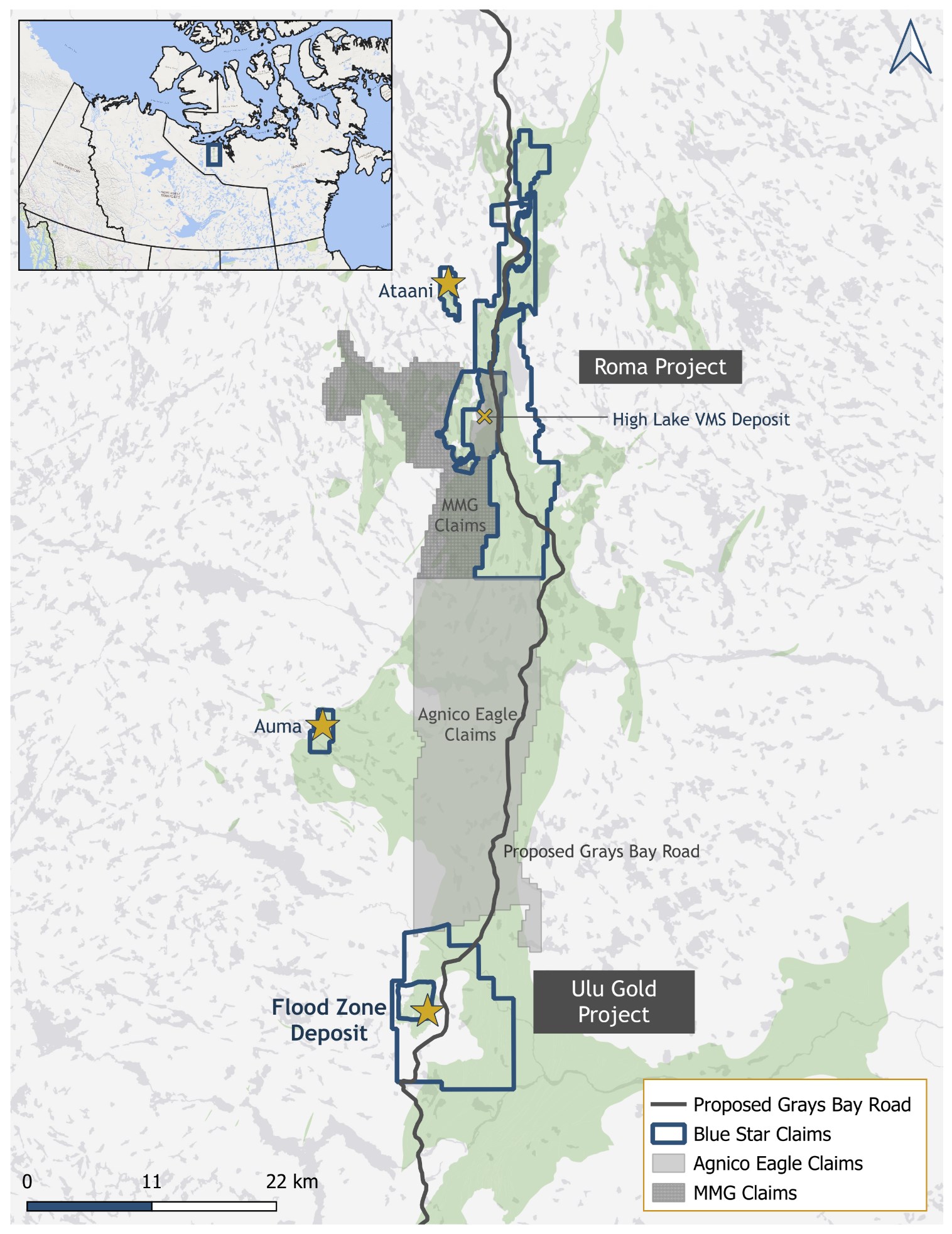
Figure 3: Location Map Showing Blue Star's Landholdings.
To view an enhanced version of this graphic, please visit:
https://images.newsfilecorp.com/files/2421/247186_48bc8023e47a1891_005full.jpg
About Blue Star Gold Corp.
Blue Star is a mineral exploration and development company focused in Nunavut, Canada. Blue Star's landholdings total 290 square kilometres of highly prospective and underexplored mineral properties in the High Lake Greenstone Belt. The Company owns the Ulu Gold Project, comprised of the Ulu Mining Lease and Hood River Property, and the Roma Project. A significant high-grade gold resource exists at the Flood Zone deposit (Ulu Mining Lease), and numerous high-potential exploration targets (gold and critical minerals) occur throughout the Company's extensive landholdings, providing Blue Star with excellent resource growth potential. The site of the future deep-water port at Grays Bay is 40 - 100 km to the north of the properties, and the proposed route corridor for the all-weather Grays Bay Road passes close by the Roma and Ulu Gold Projects.
Blue Star is listed on the TSX Venture Exchange under the symbol: BAU, the U.S. OTCQB Venture Market under the symbol: BAUFF, and on the Frankfurt Exchange under the symbol: 5WP0. For information on the Company and its projects, please visit our website: www.bluestargold.ca.
For further information, please contact:
Grant Ewing, P. Geo., CEO
Telephone: +1 778-379-1433
Email:
Neither the TSX Venture Exchange nor its Regulation Services Provider (as that term is defined in the Policies of the TSX-Venture Exchange) accepts responsibility for the adequacy or accuracy of this Release.
CAUTIONARY NOTE REGARDING FORWARD-LOOKING STATEMENTS AND INFORMATION
This press release contains "forward-looking statements" within the meaning of applicable securities laws. Forward-looking statements can be identified by words such as: "anticipate," "intend," "plan," "goal," "seek," "believe," "project," "estimate," "expect," "strategy," "future," "likely," "may," "should," "will" and similar references to future periods. Examples of forward-looking statements include, among others, statements we make regarding prospective income and revenues, anticipated levels of capital expenditures for the fiscal year, expectations of the effect on our financial condition of claims, litigation, environmental costs, contingent liabilities, and governmental and regulatory investigations and proceedings, and estimates of mineral resources and reserves on our properties.
Forward-looking statements are neither historical facts nor assurances of future performance. Instead, they are based only on our current beliefs, expectations, and assumptions regarding the future of our business, plans and strategies, projections, anticipated events and trends, the economy, and other future conditions. Because forward-looking statements relate to the future, they are subject to inherent uncertainties, risks, and changes in circumstances that are difficult to predict and many of which are outside of our control. Our actual results and financial condition may differ materially from those indicated in the forward-looking statements. Therefore, you should not rely on any of these forward-looking statements. Important factors that could cause our actual results and financial condition to differ materially from those indicated in the forward-looking statements include, among others, the following: economic and financial conditions, including volatility in interest and exchange rates, commodity and equity prices and the value of financial assets, strategic actions, including acquisitions and dispositions and our success in integrating acquired businesses into our operations, developments and changes in laws and regulations, including increased regulation of the mining industry through legislative action and revised rules and standards applied by the regulatory bodies in Nunavut, changes in the price of fuel and other key materials and disruptions in supply chains for these materials, closures or slowdowns and changes in labour costs and labour difficulties, including stoppages affecting either our operations or our suppliers' abilities to deliver goods and services to us, as well as natural events such as severe weather, fires, floods and earthquakes or man-made or other disruptions of our equipment, and inaccuracies in estimates of mineral resources and/or reserves on our mineral properties.

To view the source version of this press release, please visit https://www.newsfilecorp.com/release/247186
